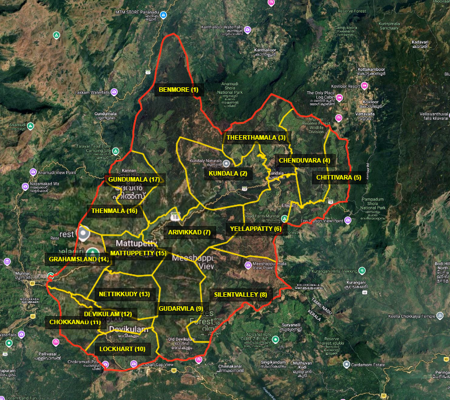
Map 2025
Devikulam Grama Panchayat – Ward Delimitation
As per the Order dated 15-05-2025 issued by the Delimitation Commission, Devikulam Grama Panchayat has been divided into 17 wards.
Ward Numbers and Names
| Ward No. | Ward Name |
|---|---|
| 1 | Benmore |
| 2 | Kundala |
| 3 | Theerthamala |
| 4 | Chenduvara |
| 5 | Chittivara |
| 6 | Yellapatty |
| 7 | Aruvikkad |
| 8 | Silent Valley |
| 9 | Gudarvila |
| 10 | Lockhart |
| 11 | Chokkanad |
| 12 | Devikulam |
| 13 | Nettikkudy |
| 14 | Grahamsland |
| 15 | Mattupetty |
| 16 | Thenmala |
| 17 | Gundumala |
How to Read the Map
The numbers shown on the map indicate the respective wards.
Northern Region
- 1 – Benmore
- 3 – Theerthamala
- 5 – Chittivara
- 6 – Yellapatty
These are mountainous areas located close to the Kanthalloor and Vattavada boundaries.
Eastern Region
- 2 – Kundala
- 4 – Chenduvara
These areas are located close to the Vattavada boundary and the Kundala Dam region.
Central Region
- 7 – Aruvikkad
- 8 – Silent Valley
- 9 – Gudarvila
- 10 – Lockhart
- 12 – Devikulam
These constitute the major central mountainous and plantation areas of the Panchayat.
Southern and South-Western Region
- 11 – Chokkanad
- 13 – Nettikkudy
- 14 – Grahamsland
- 15 – Mattupetty
- 16 – Thenmala
- 17 – Gundumala
These areas include regions adjoining Munnar, Mattupetty, and Marayoor.
Main Objectives of the Delimitation Order